

Journeys Through Three Ancient Cities
Journeys Through Three Ancient Cities
Istanbul, Delhi, and London

All photo credits are mine (Istanbul, 2023 and Delhi, 2019) except for the maps and the two open-source aerial pictures of Vijayanagara and Lisbon.
Over the past few years, I have had the pleasure of spending a week each in three large, ancient, imperial cities: Istanbul, Delhi, and London. In each city, I stayed in a relatively central location, and then explored by foot and public transportation. This is undoubtedly a different experience than joining a tour, and much more satisfying. The three cities have their differences, but also have some surprising similarities. Both London and Istanbul were Roman cities that eventually developed into medieval capitals. Istanbul and Delhi were both the imperial capitals of “gunpowder,” Turkic-run Islamic Empires in the early modern era. All three are old cities that have been inhabited for thousands of years, and each was (or is) the imperial capital of a large empire or country. I chose these three cities, omitting other cities I’ve been to recently, because of their interesting commonalities. Here are my reflections on the cities, their nature, and on the broader topic of urban spaces.
Of the cities written about in this post, Istanbul is the one that I visited the most recently, just a month ago at this writing. Going to Istanbul has been a lifelong dream of mine and it did not disappoint. It is one of the great cities of the world, and while it might not be the greatest city today, I think that if one takes a birds-eye view of history, it is certainly a strong contender for the greatest city in history.
The best thing about Istanbul is how multiple layers of civilization and history all come together tightly in a single, easily navigable city. You can walk to almost all the interesting sites in under an hour. It was an imperial capital continuously of two great empires for almost 1,600 years. One cannot say this of Delhi or London or Rome or Beijing or Tokyo or Tehran or Moscow or Paris or…well, you get the point.

In Istanbul, there’s the Roman capital Constantinople, and then there’s the Ottoman capital Kostantiniyye—less formally known as Istanbul, from the Greek eis tin polin (into the city)—intertwined in the same space: obelisks, mosques, and aqueducts are all right next to one another. The status of the city as the great city of its era is reflected in some of the interesting alternative names it has, such as Tsargrad (City of Caesars) in Slavic languages and Takht-e-Rum (Throne of the Romans) in Persian.
Interestingly, the old Ottoman architecture for public buildings is distinctively European-esque, or at least recognizably Balkan-Anatolian in a way that is immediately distinct from neighboring Arab or Persian architecture. Ottoman architecture is also characteristically lithe and airy. There’s also a newer, more modern European city that sprung up in the 19th century in Beyoğlu (which includes Karaköy, i.e. Galata) to the north of the old city, and where the former Genoese trading colony of Pera used to be. In modern times, this includes the highly fashionable and walkable Istiklal Avenue, which leads to the spacious Taksim Square.
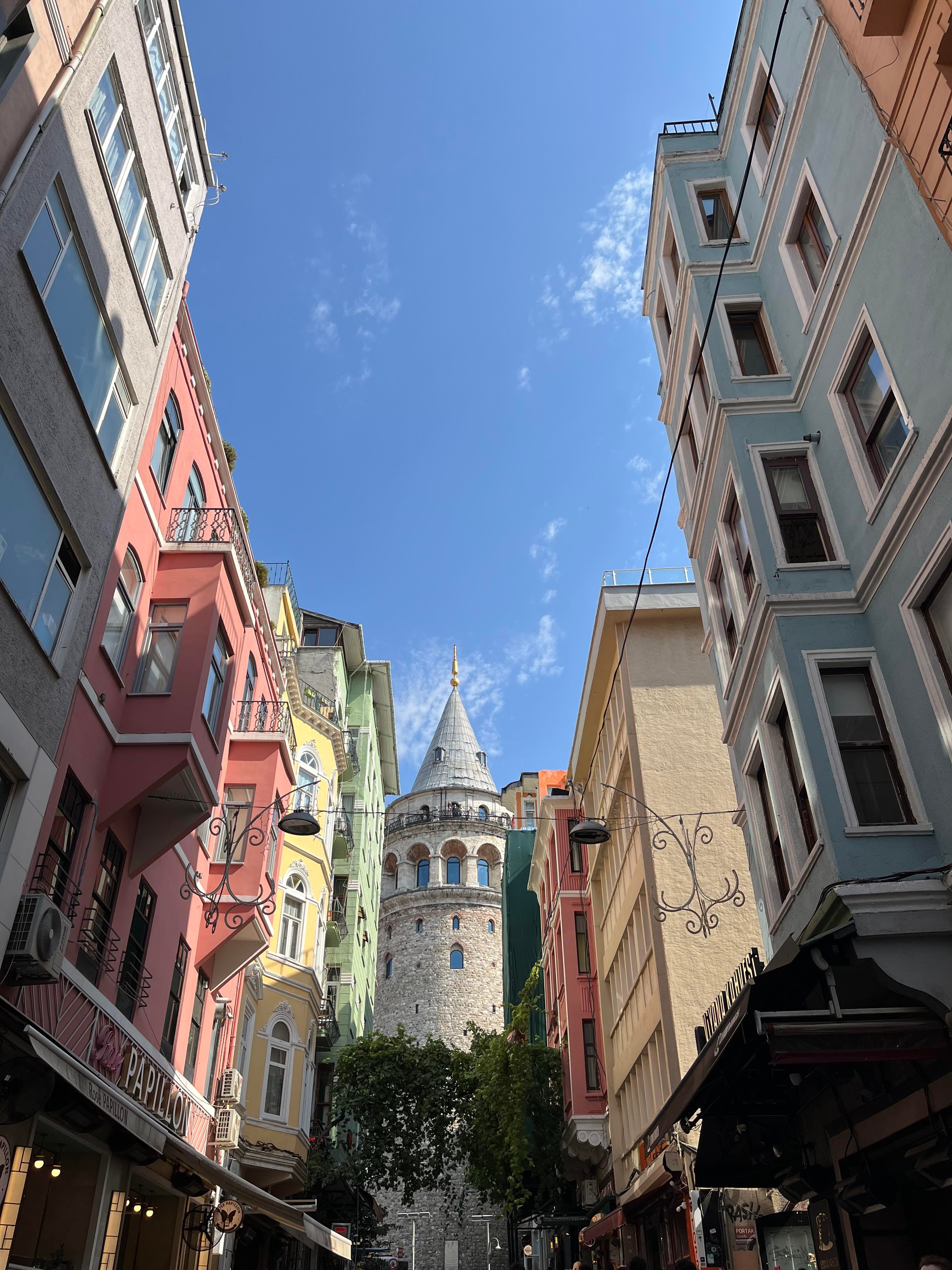
For the visitor, Istanbul is very walkable and filled with a plethora of interesting sights. I’ve seen better-preserved Roman sites elsewhere and equally interesting Islamic architecture in other countries, but it is all mashed up together here. This is true even when one leaves the touristy area where Hagia Sophia and Topkapi Palace are located. I walked past a hotel famous for housing travelers on the Orient Express in one part of town; in another part of town, I went inside the headquarters of the Ecumenical Patriarch of Constantinople, considered the primus inter pares (first among equals) among the heads of the several autocephalous churches which compose the Eastern Orthodox Church (the Patriarch remained in Istanbul after the Ottoman conquest). The public transportation in Istanbul is great: subway trains and trams are everywhere, and come every few minutes.
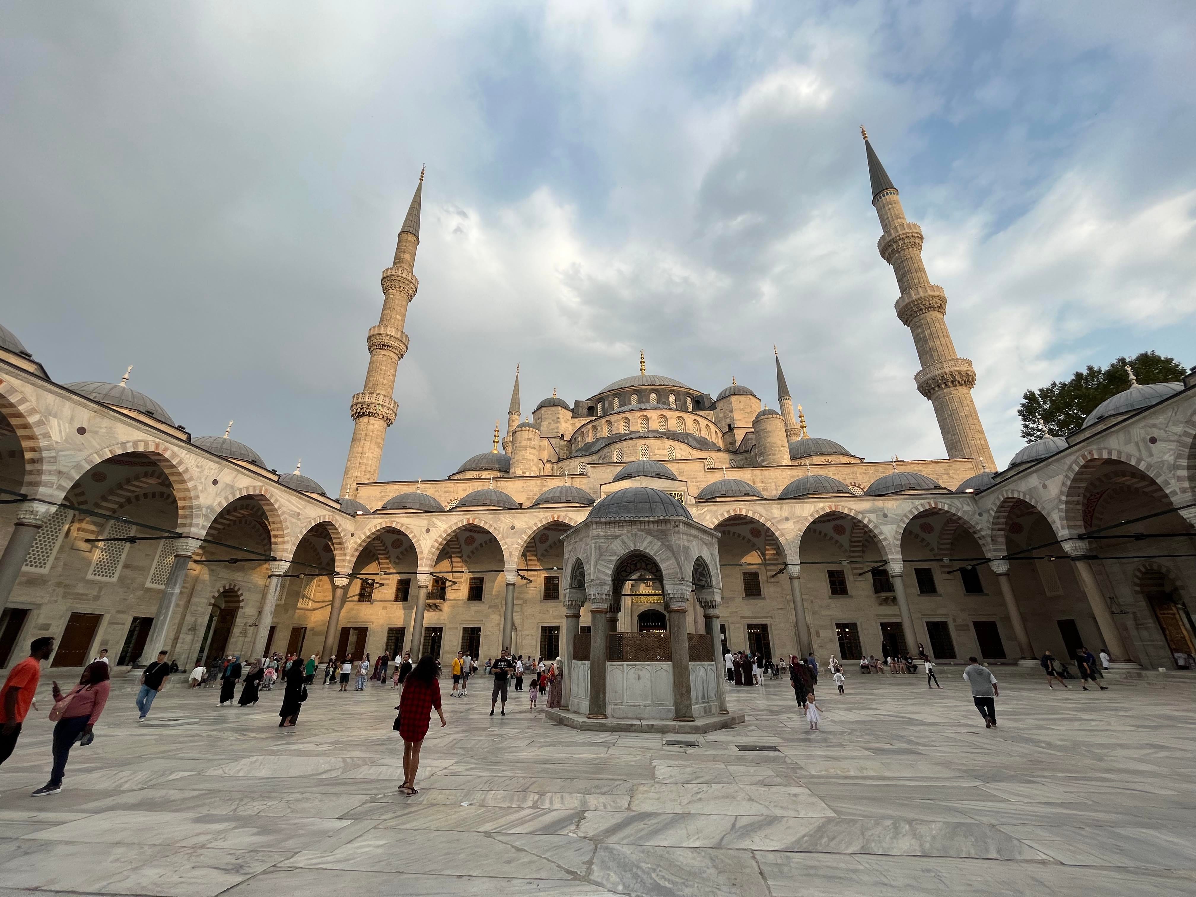
Istanbul has been inhabited for over 2,500 years, beginning with the independent Greek city-state of Byzantium, which later came under Roman rule before being chosen by the Emperor Constantine as the capital of the eastern empire. This wasn’t some spontaneous decision, and Constantine laid the groundwork for a mega city that would remain an imperial capital for centuries thereafter. Almost nothing of the pre-Constantinian city survives except a “Column of the Goths.” The Hippodrome of Constantine, now Sultanahmet Square, is a big public square near Hagia Sophia and the Blue Mosque (Sultanahmet Mosque). The Grand Bazaar is a few minutes to the east. (Hagia Sophia itself is a marvel of architecture and history. I visited several times and spent a few hours in it looking at its architecture, dome, and mosaics. There are several other large churches throughout the world now, but Hagia Sophia was the largest church in the world for centuries. There is something truly wonderful about the cavernous feeling one gets upon entering a large church or cathedral, somber and alternating patterns of light and dimness. This feeling is unique to cathedrals and somehow does not map to mosques of similar size and structure. Well, every religion’s places of worship have their own unique vibe.)

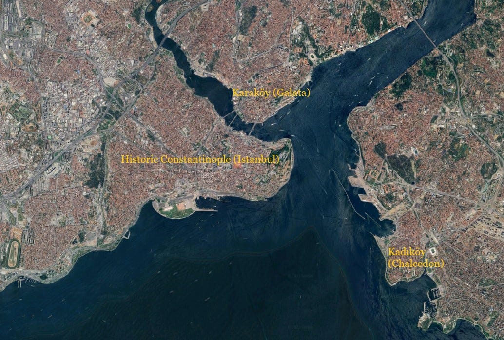
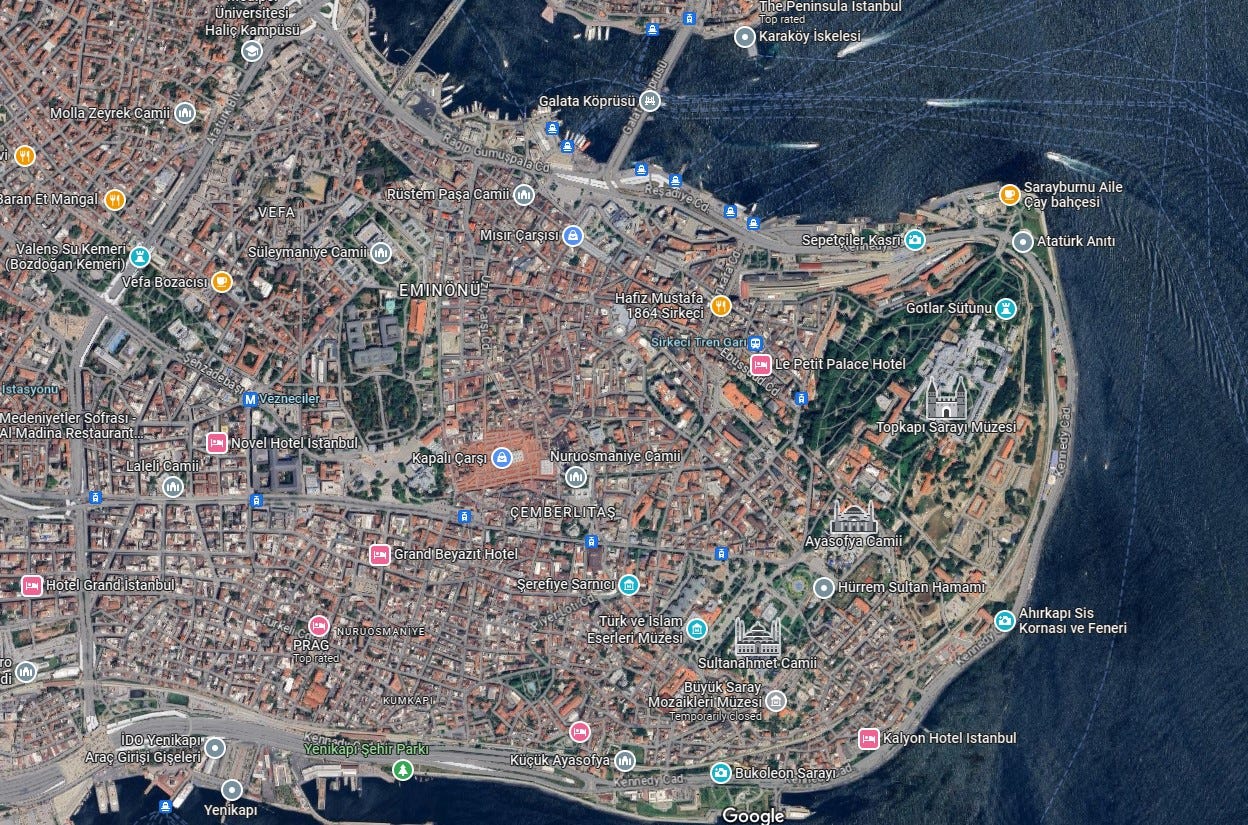
As one can see in the map below, Istanbul is a very distinctively shaped city, in a way that is only possible for cities built along coasts or mountains. On the western edge of the old city, it is still largely bounded by the ancient walls that withstood breach for a thousand years.
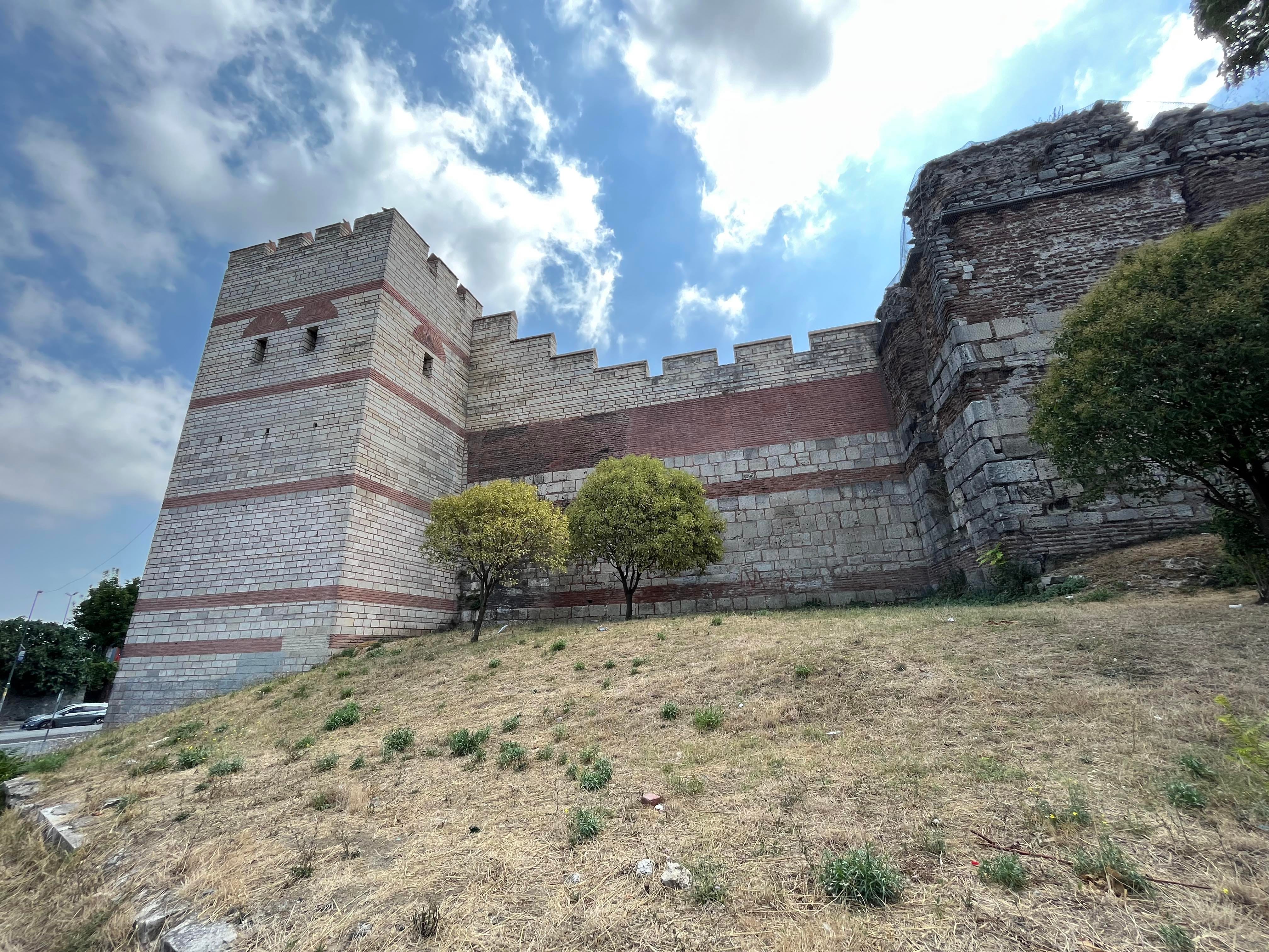
In fact, the geography of Istanbul is almost singularly famous among cities in the annals of world history because it is responsible for the city’s defensibility. It is situated at the tip of a peninsula along the Bosporus, the strait that separates the Black Sea from the Sea of Marmara and thence the Mediterranean; it is the only sea route between the Black and Mediterranean seas. To the north of the old city is the Golden Horn, a large inlet; in medieval times, a large chain prevented ships from entering it during times of war (it was from this direction that the Crusaders breached Constantinople in 1204). If the reader scrolls down below, they will notice that Delhi and London are a lot more amorphous, despite being situated on major rivers. This is true of most large modern cities. I suppose that if one were to zoom out a bit and look at the entire Istanbul metro area, it would also seem to sprawl in every direction.
Let us come now to old Istanbul (today’s Fatih District). In 1453 CE, the Turks captured Constantinople after an epic siege, and it became the capital of the Ottoman Empire. As much of the city had become derelict during the final decay of the Eastern Roman (Byzantine) Empire, much of the city was refilled and repopulated by the Turks. Ottoman Istanbul grew up and around the preexisting layout, but also when necessary, the Ottomans bent the original plan of the city to their needs. For example, the Ottoman imperial palace from the 1460s to 1856, Topkapi Palace, was built from scratch on a promontory. (As an aside, in addition to exploring the great cities of the world by foot, I also enjoy going to their museums, and Topkapi, which is now a museum, did not disappoint. The well-preserved palace grounds have exhibits on calligraphy, clothing, weapons, the harem, and the kitchen, in addition to relics from the Islamic world. Five out of five experience.)

In the map below, one can see Topkapi at the northwestern edge of the city, with Hagia Sophia and the Blue mosque to the southwest. A straight road, from Roman times, runs east-west from Hagia Sophia toward the walls. The Grand Bazaar and Istanbul University are immediately to the north of this road just a few minutes to the west of Hagia Sophia. This was the heart of the old Ottoman city, containing hundreds of thousands of people.
Regarding the Ottoman city, the following is quite interesting:
“The Romans, like the Greeks before them, conceived of the urban environment as a reflection of their civilization. It was a place for citizens to live, flourish, and interact with the state. It was also a space that celebrated their cultural and political achievements, be it in the Hippodrome, the baths, or the forums. The Turks had no such concept. Traditionally, Muslim city-dwellers differentiated themselves from rural farmers and nomads, but did not see themselves in a direct relationship with the city or its rulers. Sultans, therefore, did not beautify the streets or adorn open areas of their capital with colonnades and artwork. The notion of city planning was alien to them. Ottoman Constantinople’s only straight road was Divan Yolu—the ancient Mese, which was itself the end of the Roman Via Egnatia. Everything else was a snarl of dirt backways and a few cobbled wider streets that snaked through the city. It was up to the locals to work out the roadways, although occasionally the government would knock down homes that were in the way.” —Istanbul: City of Majesty at the Crossroads of the World by Thomas F. Madden
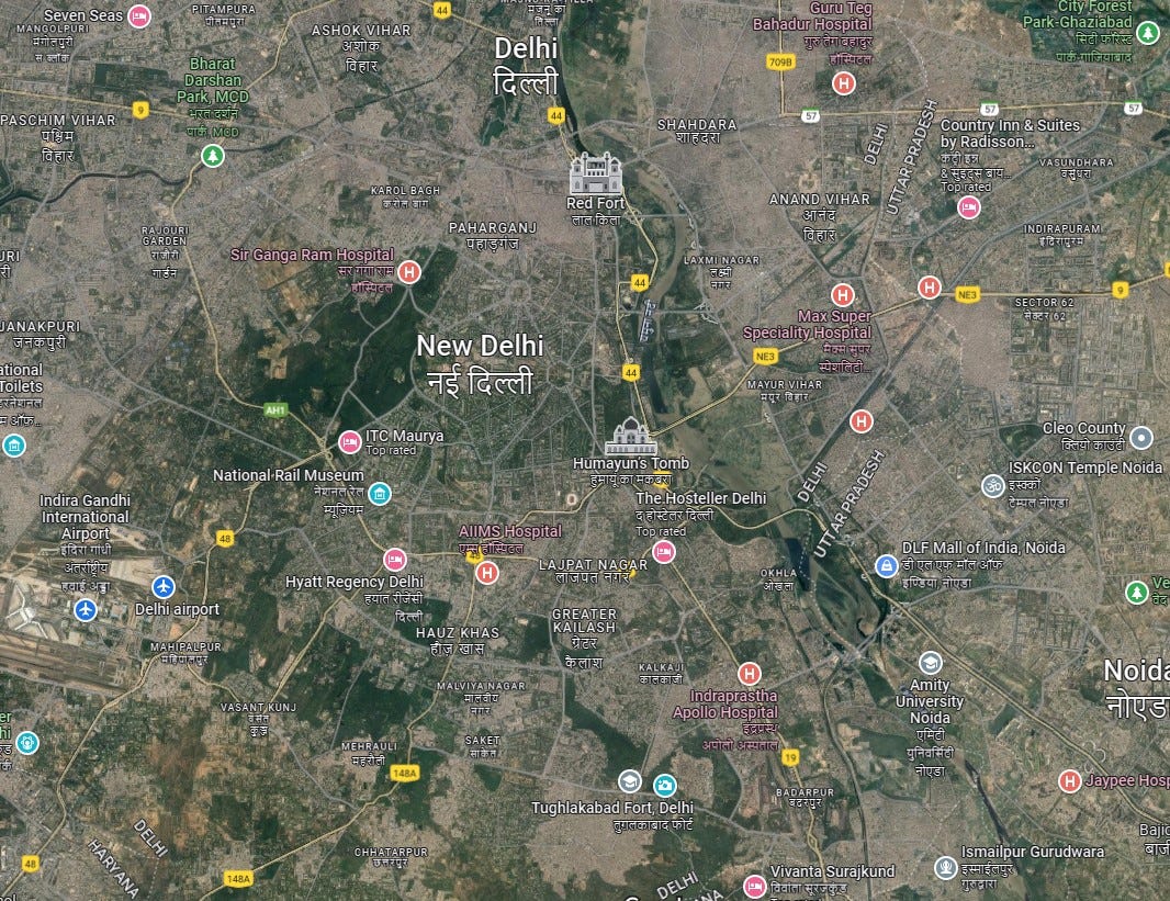
This is not to say that Islamic cities did not have their own common features and elements of planning. Traditionally, Islamic cities were built around two nodes, a mosque, often surrounded by a market, and a citadel. This is evident in both Delhi (see maps and images below) and Istanbul, which in fact follow a very similar pattern in respect to where their main citadels and mosques are located. Topkapi Palace and the Red Fort of Delhi are both situated near waterways, and command a view over both their cities and the water bodies (the Bosporus and the Yamuna River respectively). Istanbul and Old Delhi sprawl outward from the citadels toward the main mosques—Hagia Sophia and the Blue Mosque in Istanbul and the Jama Masjid in Delhi—and then beyond into winding, cobblestoned cities. Again, in both Istanbul and in Delhi, there is a giant marketplace west of the citadel and north of the main mosque: the Grand Bazaar in Istanbul and Chandni Chowk in Delhi.
Lest any of this be seen as criticism in relation to Greco-Roman cities, the great urban historian Lewis Mumford believed that medieval cities came closer to “ideal” cities than ancient and modern cities; by ideal, they fulfilled the purpose of the city as an organic space of social connectedness. Mumford also pointed out that “early cities did not grow beyond walking distance or hearing distance” until the 19th century. These cities were “long limited to a number [of people] who could promptly respond to a summons from headquarters. Mesopotamian cities had an assembly drum, just as medieval cities used a bell in a church tower to call their citizens together….” Other common features of premodern cities included walls in most places and a lack of detached housing.
Medieval cities—at least in Europe, the Middle East, and in India—evolved organically with their development being guided by the needs of their inhabitants rather than a predetermined plan. They had specialized quarters and streets for different types of crafts and arts and market squares that served both an economic and social function. Their development was thus guided by the needs of their inhabitants, sometimes in ways that would not seem obvious to us. For example, winding streets help regulate the extremities of temperature. Mumford notes that winding streets keep cities warmer than straight streets. Conversely—this is something I experienced in India—winding, narrow streets also help keep a city cool and shady. Furthermore, one can walk the length of most medieval cities in an hour or less; I walked from the outer walls of Istanbul to Topkapi Palace on the other edge of the old town in about one and a half hours. As per Mumford, their small sizes helped forge social bonds between individuals that are impossible in larger cities. Mumford said that in larger, modern cities, many interactions have to be preplanned, whereas in medieval cities, these were serendipitous, thus reinforcing social relationships.
Here, to state my own perspective, while I am very much sympathetic to Mumford’s views, I also appreciate megalopolises and recognize them to be part of modern conditions. I do think Mumford’s ideas can be adopted to large cities in that their constituent sections can each be walkable and compact, while connected with the other parts of the city through subways and other good public transportation. Note this is not polycentrism, or the idea that cities should have several disparate urban spaces that replicate the same functions, such as Los Angeles, one of most poorly structured cities in the United States.
Rather, consider how some large cities today such as Tokyo, Chicago, and New York City are set up, and how I felt many of the other parts of Istanbul were structured, such as Üsküdar on the Asian side of the Bosporus and Beyoğlu across from the Golden Horn; however, both are still fairly close to the original city, and I cannot speak to certainty how the more far-flung suburbs are integrated into Istanbul. However, in New York, there is a hub in lower Manhattan, and then several spokes that form relatively self-contained and walkable neighborhoods such as Williamsburg and Long Island City. As New York City grew in the 1800s, downtown Manhattan itself extended seamlessly into the newer Midtown Manhattan, just like Fatih extends into Beyoğlu.
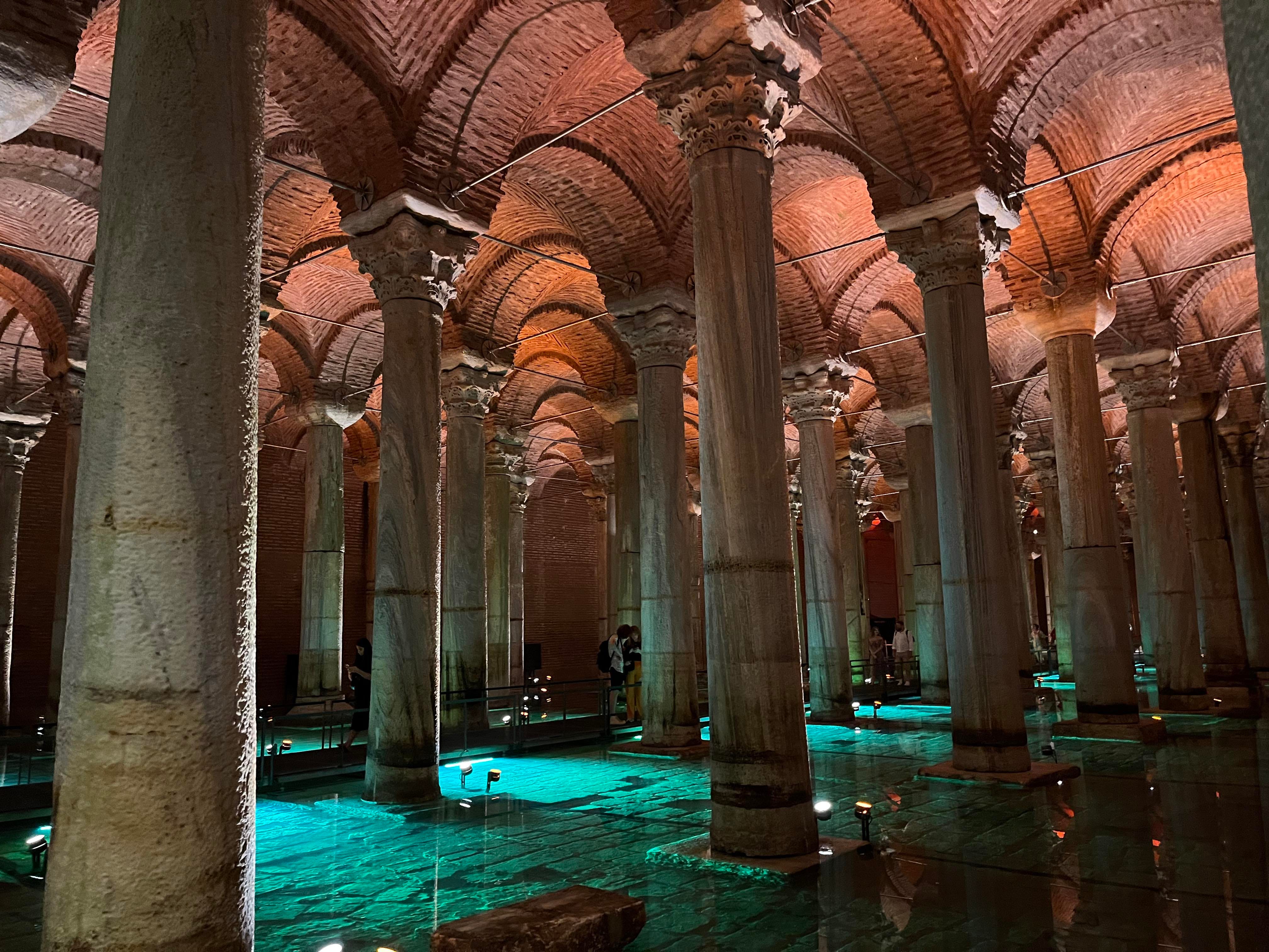
One other neat thing that I liked about both Istanbul and Delhi is observing how they used their own distinct ancient techniques to store water. Istanbul has its cisterns and Delhi has its baolis or stepwells. And with this, this post continues on to Delhi…

Delhi is one of the greatest cities to visit, although one wouldn’t initially feel that way. Compared to other places even in India, such as Agra, Rajasthan, Mumbai, and Goa, Delhi isn’t seen as a tourist magnet. Alas, because, as in Istanbul, one can walk through thousands of years of history in one city. But, there are a great many differences. To start with, Istanbul has existed as a single, evolving city for thousands of years whereas Delhi has been the site of multiple disjointed and parallel cities that are only now being stitched together by sprawl. Historically, Delhi has been the site of multiple cities; by some counts seven, by other counts, eleven. Ottoman Istanbul integrated and built on and weaving through Roman Constantinople whereas Delhi has often been described as a city of ruins that has been engulfed by the bustling modern city. This is not unusual in India, where cities and towns seem to come and go as per the needs of a kingdom or dynasty; where circumstances change, settlements shift, and the people along with them. Settlements decay, and buildings are taken apart, moved, reused. Istanbul feels old; Delhi feels ancient, timeless, predating history, whereas in reality, much of “old” Delhi dates from 1200-1700 CE (though some of the older excavated sites go back to 1000 BCE), and is thus newer than the Roman Constantinople built between the 4th and 6th centuries CE. Part of this may be due to the lack of surviving detailed records and the fact that Delhi was not an important city or capital until the 12th century. So nobody really knows—although archeologists have their guesses, many of which are fairly accurate—when and by whom many monuments in Delhi were built. One example of this is the stepwell pictured above at the end of the last section of this post, although the estimate is the 14th century.
The British Viceroy Lord Curzon said that “the whole environment of Delhi is a mass of deserted ruins and graves, and they present to the visitor, I think, the most solemn picture you can conceive of the mutability of human greatness.” More latterly, novelist Rana Dasgupta wrote in Capital: The Eruption of Delhi that
“The capital of a fast-growing and dizzyingly populous nation it might be, but Delhi’s writers have consistently seen it as a city of ruins and they have directed their creativity to expressing that particular spiritual emaciation that comes from being cut off from one’s own past. This is both the reality and the fantasy of Delhi: the city is always already destroyed.”
This is not to suggest that modern Delhi—one of India’s most developed, largest, and bustling cities—is a decaying ruin with poor quality of life, but that it gives off the vibe of being “ruined.” Dasgupta quotes the impression of Emma Roberts, a 19th century British traveler:
The capital of the Mughal empire . . . the modern city, or Shahjahanabad, the designation by which it is distinguished by the natives, who have not yet fallen into the European habit of calling it New Delhi . . . stands in the centre of a sandy plain, surrounded on every side with the ruins of old Delhi, curiously contrasted with a new suburb, the villas belonging to Europeans attached to the residency, and with the cantonments lately erected for three regiments of sepoys . . . From the summit [of the Qutub Minar] the view is of the most sublime description; a desert, covered with ruins full of awful beauty, surrounds it on all sides, watered by the snake-like Yamuna, which winds its huge silvery folds along the crumbling remains of palaces and tombs. In the back-ground rise the dark lofty walls and frowning towers of an ancient fortress, the stronghold of the Pathan chiefs; and the eye, wandering over the stupendous and still beautiful fragments of former grandeur, rests at last upon the white and glittering mosques and minarets of the modern city, closing in the distance, and finely contrasting, by its luxuriant groves and richly flowering gardens, with the loneliness and desolation of the scene beneath. Before the Mohammadan invasion, [this collection of collapsed cities] had been a place of great renown, many of the remains of Hindu architecture dividing the interest with those of the Muslim conquerors: the sepulchres of one hundred and eighty thousand saints and martyrs, belonging to the faithful, were, it is said, to be found amidst the wrecks of temples and palaces, before all had crumbled into the undistinguishable mass which now renders the greater part of the scene so desolate . . . From the outside the view [of Shahjahanabad] is splendid; domes and mosques, cupolas and minarets, with the imperial palace frowning like a mountain of red granite, appear in the midst of groves of clustering trees, so thickly planted that the buildings have been compared, in Oriental imagery, to rocks of pearls and rubies, rising from an emerald sea. In approaching the city from the east bank of the Yamuna, the prospect realizes all that the imagination has pictured of Oriental magnificence; mosques and minarets glittering in the sun, some garlanded with wild creepers, others arrayed in all the pomp of gold, the exterior of the cupolas being covered with brilliant metal, and from Mount Mejnoon, over which a fine road now passes, the shining waters of the Yamuna gleaming in the distance, insulating Salimgarh, and disappearing behind the halls of the peacock-throne, the palace of the emperors, add another beautiful feature to the scene . . . [But] the glory of the Mughals has faded away, and their greatness departed . . . The celebrated gardens of Shalimar, with their cypress avenues, sparkling fountains, roseate bowers, and the delicious shade of their dark cedars, on which Shah Jahan, the most tasteful monarch in the world, is said to have lavished a crore of rupees (a million sterling), have been almost wholly surrendered to waste and desolation.
Although much has since changed, my impressions from the last time I visited Delhi—four years ago—were similar. It is quite an experience to go from a soulless, modern concrete development to an ancient ruin within a minute, like experiencing a quilt that has been put together from many different cloths.
The city of Delhi—officially the National Capital Territory (NCT) of Delhi is comparable in size to modern Istanbul and London, but feels like a collection of towns and cities that were bureaucratically designated to be contemporary Delhi. Modern London has grown out from its core, but two centuries ago, it grew in, filling up the agricultural land between the cities of the then City of London and Westminster. Likewise with Delhi. This is different than many other major cities, the sprawl of the modern city is primarily a result of the city growing outward from its core, adding or incorporating suburbs.
Delhi lies near the convergence of the ancient northwest-southeast (uttarapatha) and north-south (dakshinapatha) routes of subcontinent, i.e. the the routes used by traders and armies to go from Punjab down the length of the Gangetic valley to Bengal and from the Gangetic valley through Rajasthan, Malwa, Gujarat, and then the Deccan Peninsula.
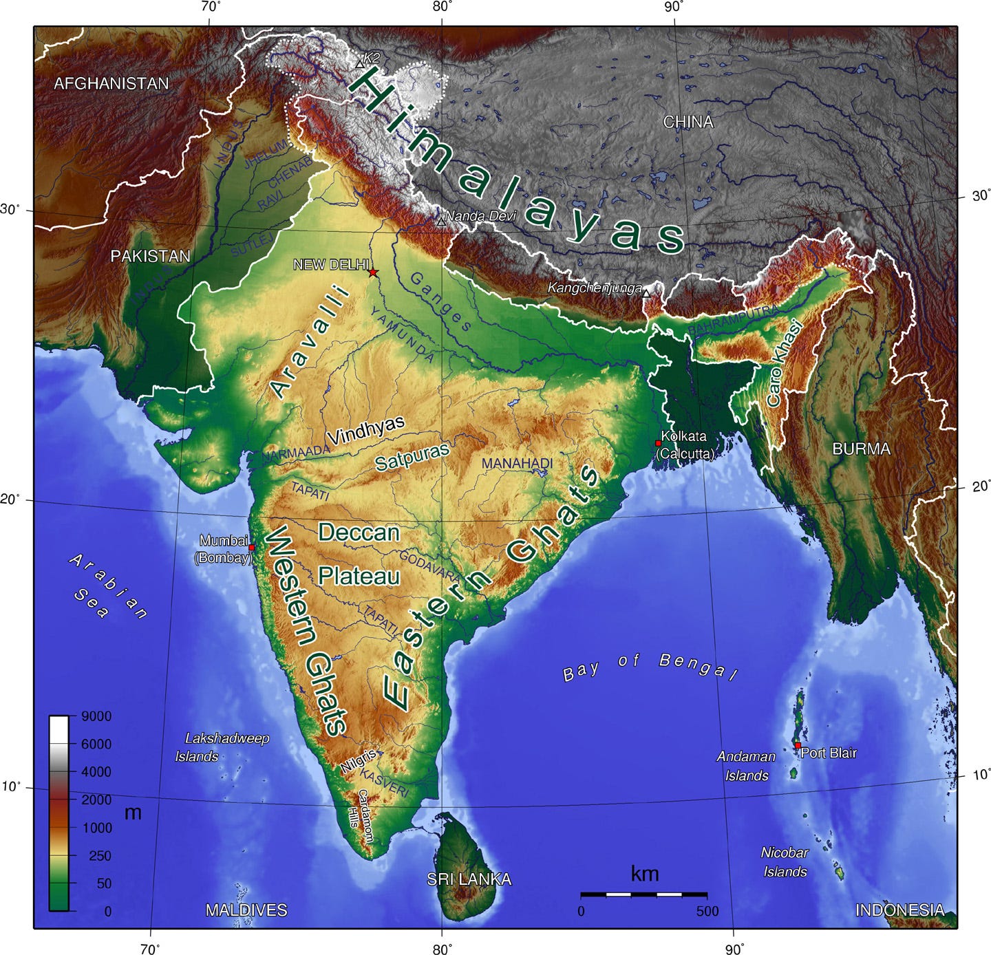
The first incarnation of Delhi is said to be the city of Indraprastha, a city described in the Sanskrit Mahabharata as a capital of the protagonists, the Pandavas. Many sites from the Greek epics were considered fictional, but the German archaeologist Heinrich Schliemann established the likely historicity of places like Troy and Mycenae in the 19th century (we won’t get into all the controversies surrounding his work here). This is not to suggest that the events of the Iliad are historically verifiable but that they are at least rooted in real places, cultures, and events that were then heavily mythologized and embellished over several centuries and in a manner resembling the “telephone game.” The same can be said of the Mahabharata, and it is now fairly well established that some of the underlying background of the Mahabharata is historical. The weight of archaeology, toponymy, and history thus all credence Indraprastha was located in Delhi, and archeologists have discovered artifacts from the Iron Age indicating that there was a thriving settlement along the banks of the Yamuna River from 1000 BCE onward, although it probably eventually became just a regional city. Delhi is located at the northern edge of the Aravalli Range, which then extends south through Haryana into dry and hilly Rajasthan. Delhi may have been chosen as a settlement site more for its location than for its abundant natural resources. According to the Mahabharata, it was initially Khandavprastha. It was described in Section 199 of the Adi Parva (Book 1) of the Mahabharata as a “terrible forest (ghoraṃ vanaṃ).” Upon its reclamation, it was renamed Indraprastha, city of Indra, the lord of the celestial devas.
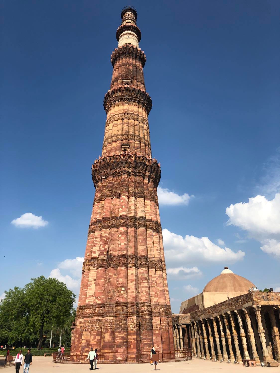
A more recognizable Delhi, including parts of a fort that have survived to the present day, date to the 10th-11th centuries CE and were built by the Hindu Tomar Dynasty, before passing to the Chauhan Dynasty. Qutb-ud-Din Aibak captured Delhi from the Chahamana (Chauhan) dynasty in 1192 CE on the behalf of the Ghurid Sultanate, eventually founding his own breakaway Delhi Sultanate in 1206 CE. For the first time, Delhi became the capital of a large and expanding empire, and has traditionally been the seat of Muslim power in India, with both the Delhi Sultanate and the subsequent Mughal Empire ruling over large parts of the subcontinent. It was probably chosen for its convenient location for an army en route from Central Asia to northern and central India. At first, Aibak’s Delhi was built in the same area, today’s Mehrauli neighborhood, where the previous Delhi used to be, in the pre-Islamic fort today known as Qila Rai Pithora. One can find the Qutb Minar and other early 13th century monuments in this area. Like many other future cities in Delhi, the Qutb Minar was built from recycled stones from the cities that preceded it.
The city then began to “move” as new Delhis were built by subsequent rulers at different spots. Siri (“Head” because it was allegedly built with the severed heads of Mongols killed in battle), built by Alauddin Khilji around 1300 CE was three miles north. Half a century later, the city moved to Jahanpanah (“Refuge of the World”), two and a half miles east of Qutb Minar. By the time the second Mughal Emperor Humayun created Dinpanah (“Refuge of Religion”) in 1533 CE, the city had moved eight miles northeast of where it was at in 1192. Dinpanah, however, was located approximately in the same place as Indraprastha in 1000 BCE. Today’s “Old Delhi,” Shahjahanabad, dating to 1648 CE, is four miles to the north of the Old Fort (Purana Qila) of Dinpanah, while most of the modern capital district of “New Delhi”is between Purana Qila and Old Delhi. Delhi had been conquered in 1526 CE by the first Mughal Emperor Babur, a Chagatai Turkic (“Old Uzbek”) speaking warlord born in Andijan in modern-day Uzbekistan. The Mughal capital moved several times for the next hundred years between Delhi, Agra, and Lahore, before being permanently settled at Delhi during the reign of Shah Jahan.

In contrast, Constantinople and Istanbul existed in the same three miles between the walls and Bosporus for almost 1,500 years. Shahjahanabad is today’s “Old Delhi,” but as Emma Roberts’s quote demonstrates, at that time, it was “New Delhi” in relation to all the other older cities in the area. Old Delhi is in many ways a quintessential “medieval” Islamic city, with its citadel, walls, one major straight road (Chandni Chowk), winding alleyways, imperial mosque, and main bazaar.

Old Delhi is characterized by mixed-use spaces and there are few standalone buildings. There are other smaller bazaars, mosques, as well as some Hindu and Jain temples (unlike in Istanbul, the different places of worship of various denominations do not seem as segregated) . There are few standalone buildings Parts of Old Delhi have also since been demolished or modified by the British including parts of the walls and some space for a railway station. In Istanbul, one visits Fatih the old city and then the new city across the Golden Horn; this is much of the experience of Istanbul. But in Delhi, Old Delhi is really just one small part of the entire experience.

All of the Delhis and their ruins are now encompassed within the modern Delhi, a huge, amorphous mass seen below; the other satellite cities and settlements of the Delhi metropolitan area spread even further beyond; like Tokyo, it is becoming a megaregion of urbanity.
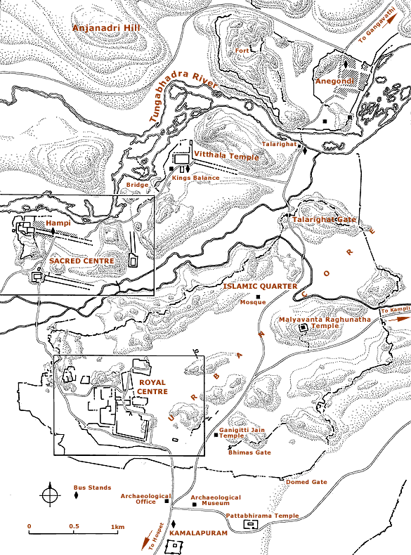
Unfortunately, Delhi is a prime example of a city that could have been very pleasant to walk through, but is not due to the fact that much of the stitching together between the villages and towns of what is today’s Delhi was not organic. Rather, it is the result of initiatives by administrators and developers. Many of these developments are single-used areas in gated residential complexes, apartments, and malls catering to the upper and middle classes, reachable only by roads, many of which are elevated. The idea is to ignore and escape the rest of the city, and “there is no true public realm, open to all,” the antithesis of Mumford’s ideal city. It is also contrary to the history of cities in the region. From the cities of the Indus Valley civilization onward through the ancient and medieval periods, Indian cities have mostly been integrated spaces à la Mumford with citadels, temples, quarters for different types of professions and artisans, and market plazas. Here are the city plans of some older, premodern Indian cities, which very much have multiple public spaces:


As I wrote some years back after my last trip to Delhi, the end result of this development in Indian cities is essentially the creation of parallel cities and spaces within the city, rather than an integrated space as one can find in Istanbul, London, or New York. Nonetheless, in certain self-contained neighborhoods, such as Hauz Khas, there is still much charm. Hauz Khas was a part of 14th century Siri, and maintains some of its layout and continuity, but has also been redeveloped in the 1980s into a modern, hip neighborhood. In fact, most Indian cities are hell for pedestrians due to the combination of traffic and developer-led compounds, but at least they have urban density, less developer-driven areas, cheap public transportation, street food, and many other things to make up for their walkability issues. I nonetheless do hope that India rediscovers its history of urban planning.
Within this jungle of antiquity and staid modernity, there lies the planned city of New Delhi, which is immediately distinguishable on a map because of its planned environment immediately to the south of Old Delhi. The British established New Delhi to serve as the capital of their Indian empire in 1911 CE. Prior to this, the capital of the British Raj was Calcutta. The preexisting prestige of Delhi, as well as its more central location, were major factors in moving the capital of the Raj.
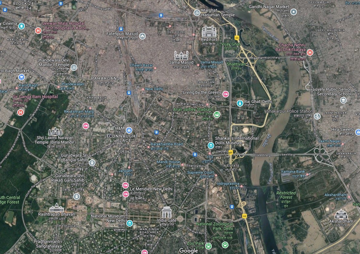
While New Delhi does not have the organicness of Old Delhi, at least it is designed for the public to use and as a public space, and although it does not have the winding alleyways and the potential for surprise discoveries that older cities have, it is not necessarily hostile to the public or to walking. In fact, New Delhi’s Central Vista bears some similarities to the city wherein I dwell, Washington DC; at least, it resembles the National Mall of DC (much of the Central Vista is currently being redeveloped). Quoting Dasgupta again:
The British city would be conceived to attract light and air to disperse the miasma: the architect, Edwin Lutyens, was a lover of the English countryside and took his inspiration from the theories of Ebenezer Howard, whose book propounding the material and spiritual advantages of garden cities was just then generating an intellectual movement on both sides of the Atlantic. Lutyens determined that Delhi would be a combination of city and countryside, like Howard’s utopia: buildings would be sparse, low, and separated by expansive gardens; wide roads and parks would keep the city fresh and well ventilated…All in all, a reversal: where Shahjahanabad’s streets were narrow and labyrinthine, New Delhi would have vast, geometrical avenues; where commerce in the old city took place in a profusion of packed bazaars, it would be confined in the new to a pillared circle, eventually named Connaught Circus. Where Shahjahanabad was a city, it could be said, New Delhi was a bureaucratic village – for though it would contain administrative buildings of stupendous size and grandeur, its dispersed, pastoral layout, whose open spaces were emptily monumental, left few places for any kind of urban bustle. There was almost no provision in the plan for venues of pleasure and congregation, nor for merchants and their trades, nor for housing for the poor – all of which had been conspicuous features of the old city.
Moving on to London…a very walkable city! I have mostly included London here for the sake of comparison. As London has been a major vehicle of modernity, global trade, and industry for centuries, not to mention English-speaking culture, much has been written about it and its history, and I have little new to add. I will say that I found London to be a very pleasant and balanced—both dense and spacious—city, multilayered in that it has many surviving buildings from the medieval, early modern, Victorian, and modern periods all occupying the same space (there are some Roman ruins but no functional buildings; the oldest building in London is part of the Tower of London, built by William the Conqueror in 1078 CE).
That being said, there are some interesting parallels to other cities that I wish to highlight. Londinium, the basis of London, originally a Roman city, shares with Istanbul its Roman heritage. However, while Constantinople was redeveloped into an imperial capital by the 4th century, London remained a relatively small provincial capital that experienced little growth outside its well-delineated walls. The original settlement was essentially abandoned after the Anglo-Saxon invasions and lay fallow for a few hundred years. As with Delhi, London initially “shifted,” and other settlements grew up nearby, such as Lundenwic. In the late 9th century, the settlement seems to have moved back within the old walls, which were then fortified and repaired, though the initial capital of the Kingdom of Wessex and then the Kingdom of England was at Winchester. By the end of the Anglo-Saxon period, London was serving as a capital, and has been since, and like Istanbul, its core has been continuously inhabited for centuries without moving about.
Thus, while London is an ancient city, both London and Delhi actually begin to appear in a familiar form only around 1000 CE. Delhi, however, continued shifting and changing forms, almost into the 20th century. Medieval London grew from its core in the old Roman city. However, and most interestingly, “London” was essentially two (or three, if one adds in South London) nearby cities for several centuries: London (today’s City of London), and the city of Westminster, about three miles away to the west, up the Thames River. London became England’s largest city and commercial center, while Westminster—where Buckingham Palace and Parliament are located—was the administrative capital. Both cities remained distinct and separated by open fields (one still observes place names in London like Lincoln’s Inn Fields), but as London grew, the area in between began to “fill in” in the 16th and 17th centuries, a situation that is not dissimilar from Delhi’s. Much of this area is today’s West End, as it is the “west end” of the City of London and includes many of London’s famous landmarks such as Trafalgar Square, the British Museum, the neighborhoods of Soho and Mayfair, and so on. The difference between London and Delhi is that London was “filled in” gradually and organically, and before the time of automobiles, so the central part of London—which includes London, Westminster, and all in between—presents as a coherent and organic city, like Istanbul. By the time of the Industrial Revolution and later, cars, London was already formed, though subsequently, it grew out, acquired suburbs, and sprawled like any other modern city.

Ironically, because London was already fully formed by the time it became a large administrative center and capital of a large empire, the British were thankfully unable to lay out an alternative, planned “New London” the way they did with “New Delhi.” Because much of the newer parts of the city were laid out in the early modern era, the streets were not particularly narrow or winding, i.e. “medieval.” Furthermore, after the Great Fire of 1666, the old street plans were largely maintained—to avoid the legal trouble of changing property boundaries—although some roads were widened. It was easier for the British to disregard property rights in Delhi than in London. These property laws might have been an important factor in preventing London from going the way of Paris during the reign of Napoleon III. Under Napoleon III’s aegis, Georges-Eugène Haussmann, an official who rebuilt and redesigned much of Paris, destroying much of the medieval city. While some of his changes were necessary for sanitation and beautification, much criticism has been levied at the scale and extent of the destruction of old Paris. The new Paris became a model for the stereotypical modern city, with its grids and long, straight boulevards. At least central Paris is walkable because its planners also wanted Paris’s people to enjoy parks and the like.
While there is certainly a role for such design, especially along the main throughways of a city, there is also charm in the ideas expressed by Mumford in regard to the ideal city. Many modern cities in North America, and now modernizing cities in Asia and the Middle East, built in or expanding in the age of the automobile, either hellscapes of urban sprawl and traffic or else so spread out so as to seem desolate or at least not really urban. There’s also an increasing body of evidence that demonstrates a correlation between proper urban planning and positive mental health. While you never know where you’ll find interesting urban spaces, it does seem as though Europe leads the way in creating cities that help people remain active and form communities.
In my own view, while I think the idealization of the medieval or ancient city has its benefits, modern cities can also incorporate more green spaces, plazas, and bike lanes: more active and green spaces, and also more open spaces, but the open spaces (like plazas) should be well integrated into the framework of the city, rather than being like the giant freeways or traffic circles that disrupt the city as an integrated urban space. While Mumford wanted cities to grow spontaneously without planning, I believe planning is necessary in modern conditions, if only to mitigate the worst aspects of sprawl and suburbanization. Washington, DC is an example of a new, planned city that is walkable. I’m very interested in seeing how The Line turns out; it is a linear city under development in Saudi Arabia that is supposed to be fully walkable and have no cars.
In the present day, it is unlikely that there are going to be radical changes—and I would prefer for urban spaces to evolve organically—but some things that can be done include: better public transportation (especially trains), revitalizing city centers, more mixed-use spaces, and pedestrianizing cities; more American cities should look like New York or Boston instead of Los Angeles or Dallas. Smaller cities or cities that are in the process of change and development should take care not to sprawl too much. They need not remain hamlets! Some of the more pleasant cities I’ve been to recently: Lisbon, Tel Aviv, Jaipur, are major cities and important administrative and commercial centers, but have avoided the pitfalls of the true megacities; maybe they have implemented the right policies, but maybe they also just avoided becoming too big, whilst remaining relatively cozy.

This post began as a walkthrough of some major cities and my impressions of them, but as J.R.R. Tolkien one said of the Lord of the Rings, “the tale grew in the telling.” There is a theory that writers tend to either be architects or gardeners, those who “plan everything ahead of time, like an architect building a house” versus those who “dig a hole, drop in a seed and water it…as the plant comes up and they water it, they don’t know how many branches it's going to have, they find out as it grows.” Readers will know which of those two types of writer the author of this post is and will hopefully indulge him and the manner that this post has unfolded. Like a medieval town and its alleyways.